When I saw the title I thought it would be easy for a Then&Now photo:
Asakusa Temple at Tokio
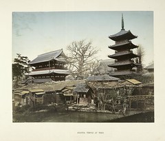
Asakusa is a huge tourist destination, I've been there a number of times. With three major buildings in view, and a body of water, it should be easy to find a ton of similar photos, and to triangulate the exact location on a map. (But already I'm thinking wait, where's that water?)
First I do some quick queries on Flickr, and comparing the angles on the buildings I come up with nothing in the first five or ten minutes.
So, next I head to a map site (both Live Maps and Google have good Tokyo maps, Google has English) to get a sense of the environment, using aerial photos.
And it just doesn't work. There's no way to get the pagoda and any of the buildings to line up like this. I know I'm looking at the right place, so what's going on?
In Nagasaki University database I get lucky this time, they have a very similar shot of Asakusa, the same pond, the same three story building. However although it has a descriptive caption, the information isn't helpful to me, and expects me to already understand the contemporary geography.
But now I can hit the search engines armed with some keywords from the Nagasaki site. The building on the left is a gate which used to go by a different name (仁王門). I search for that and pagoda (五重塔) in Japanese, plus the name of the calendar era, Meiji (明治). I'm hoping the gate name is unique enough, and the other two will scope me down.
The first result is perfect, a contemporary photo of the same location at the library of the broadcasting school Open University of Japan. In the notes, the triangulation riddle is solved: the pond was filled in during the late 1887 (another site says June, 1886), and the pagoda was burned down in US fire bombing during World War Two. It even explains that the current pagoda was built in a different location.
I continue down the results, finding other creditable references to confirm the basic facts, and finally ending up back on the National Diet Library site (many of my queries end there, like the baseballers). A wonderful photo on NDL shows me the spacial relationship between the buildings and the main shopping street, which remains today. The old pagoda is to the right. The current pagoda is about where the clock is in NDL's phtoo.
I was able to pin it to right about here, but now it's an odd spot that no one would ever post a photo to Flickr of (with discernable tags), so I'll have to stick it on my "photo next time I'm in Tokyo" list.
I was also able to narrow the photo date down to before 1887, because of the pond not being filled in yet.
